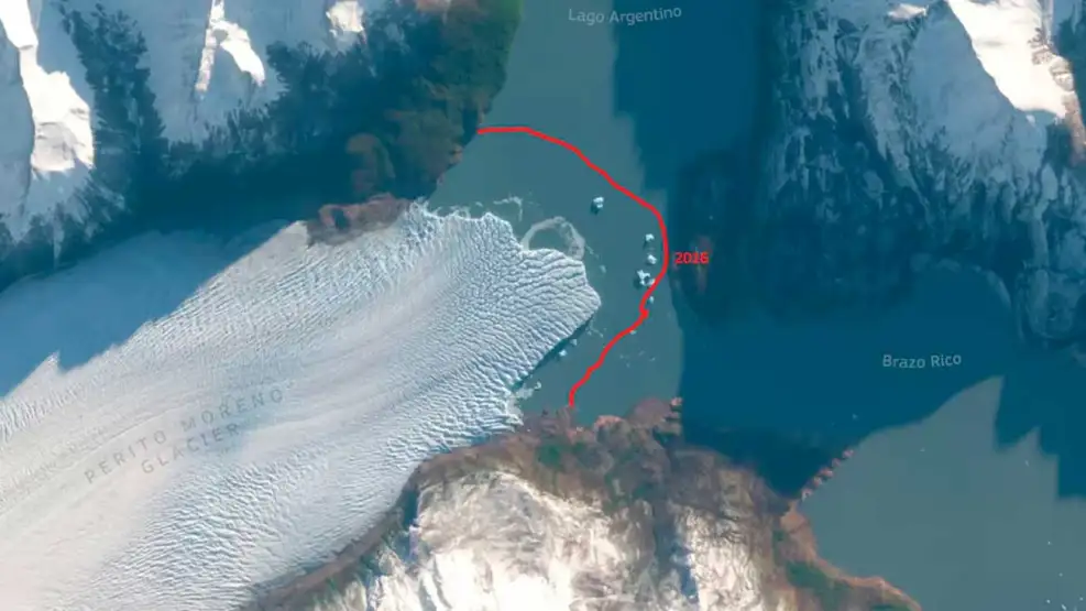
The Perito Moreno Glacier, one of the most recognized natural symbols of Argentine Patagonia, is showing a retreat that can now be identified from satellite images. Comparing the ice front in the Brazo Rico sector of Lake Argentino with records from previous years reveals a change that the scientific community had already been tracking through field measurements, radar data and remote monitoring.
For decades, Perito Moreno was considered an exception among the major Patagonian glaciers because of its relative stability. That condition has become increasingly altered in recent years. Studies based on Landsat images from 1997 to 2023 indicate that, after a period close to equilibrium, the glacier began a transition toward sustained frontal retreat in 2016.
The figures show the scale of the process. Recent research estimates that since 2019 the glacier front has retreated by more than 800 meters in some areas, while in 2025 a retreat event of nearly 385 meters was recorded, the largest within the observation period since 1997. Between 1997 and 2023, surface loss was estimated at around 3 square kilometers.
Another study on the state and fate of Perito Moreno identified a sharp increase in thinning at the glacier front: from 0.34 meters per year between 2000 and 2019 to 5.5 meters per year between 2019 and 2024. That change is linked to ice dynamics, lake depth and the progressive loss of the grounding support that helped stabilize the front for years.
The explanation does not depend on a single cause. Atmospheric warming, recent droughts, reduced snow accumulation, contact with lake waters and subglacial topography interact in a complex system. A submerged ridge or moraine appears to have acted as a natural barrier; if the glacier detaches from that support point, iceberg calving could intensify and retreat could accelerate.
This is strategic information for Argentina. The Patagonian icefields are South America’s largest solid freshwater reserve and sensitive indicators of regional climate variability. Their evolution affects ecosystems, tourism, water availability, territorial planning, safety in protected areas and the understanding of South America’s contribution to sea-level rise.
The satellite image should not be read only as a picture of loss, but as a decision-making tool. Copernicus, Landsat, Sentinel-2, radar measurements, bathymetry, weather stations and glaciological campaigns make it possible to turn a visible phenomenon into operational knowledge. The priority is to sustain data series, integrate scientific institutions and translate information into adaptation policies.
For Fundación Argentina ASE, the Perito Moreno case summarizes a central agenda: knowing the environment better in order to protect ecosystems and communities. Observation technology, territorial monitoring and scientific cooperation are not accessories; they are essential public capacities for anticipating risks, managing natural resources and sustaining human development in an austral, South American and emerging country.