
Paraguay's Ministry of Environment and Sustainable Development has opened a competition to hire technical assistance for evaluating AFOLU maps — agriculture, forestry and other land use — for the country's second Biennial Transparency Report. The National Directorate for Climate Change is managing the call and will accept applications until August 5 at 3 p.m.
The selected professional will support the technical management of the BTR2 and must submit a signed expression of interest, documented résumé, identification, financial proposal and the required forms. The call also states that applicants must have their own computer equipment to produce the deliverables, while the terms of reference and evaluation matrix provide a basis for comparing experience and price.
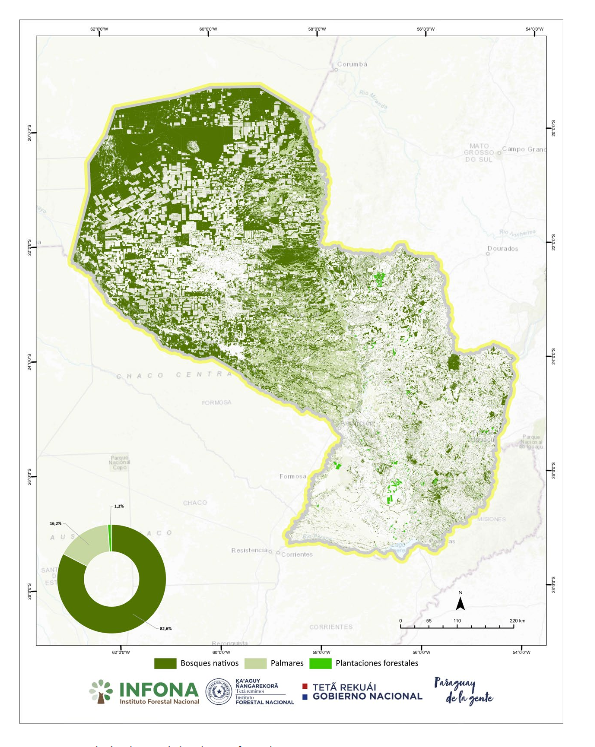
AFOLU maps are central to a climate inventory because they distinguish forests, crops, grasslands, wetlands and land-cover change. This spatial base is combined with activity data and emission factors to estimate gases released or carbon removed; classification errors, incompatible years or overlapping areas can alter the national balance.
The assignment involves more than producing a map image. For results to be auditable, sources, resolution, method, reference date, uncertainty and consistency across time series must be documented. Comparison with field observations and other official datasets helps prevent the same hectare from being counted twice or forest loss from disappearing inside a broad category.
Paraguay submitted its first BTR to the United Nations Framework Convention on Climate Change on December 27, 2024, together with its national inventory document and common tables. The second report is due by December 31, 2026, and is being prepared jointly with the Fifth National Communication under the enhanced transparency framework of Article 13 of the Paris Agreement.
The strategic value goes beyond international compliance. Comparable maps can support forest policy, territorial planning, oversight of land-use change, tracking of the national climate contribution and decisions on restoration or sustainable production. They also allow universities, producers and civil society to understand which data underpin official figures and where gaps remain.
Selection, technical map assessment, inventory integration and quality controls will follow the competition before submission. The challenge is to retain that capacity within government and keep the time series current: climate transparency is most useful when it ceases to be an isolated biennial exercise and becomes permanent infrastructure for territorial decisions.